 |
| Our Track from Edisto Island to the Hilton Head Area. |
Winds
were brisk out of the southwest at 15+ knots, producing white-capped wind waves
of three to four feet on top of dual swells running two to three feet, all at
narrow intervals. And we were punching
straight into it all….for about four hours, with frequent salt water spraying over the fly bridge. We quickly retreated
to the pilot house helm. Eventually, around 1300, we reach our turn point for
the entry channel into Port Royal sound, and that more northerly vector put the
lousy seas more to our beam – the stabilizers got a workout and the autopilot
heading control was sloppy, but we were no longer banging the bulbous bow like
a judge’s gavel.
 |
| Sunset Got Obscured by the Clouds as Showers Moved Through the Area |
About
an hour later we had ducked in behind the lee of Hilton Head Island and
intercepted the ICW for a very smooth run down to Daufuskie Island and the
Cooper River, where we turned off into Bull Creek and dropped the anchor around
1615. We set the hook on the first try
and there was only one other boat in the expansive anchorage, making for a
stress-free camping arrangement for the night. (Tides run +/- seven feet here, but Bull Creek has plenty of depth if you plan for the current swings.) A band of moderate rain showers moved through about an hour before
sunset as a cold front approached the area, but we were closed up with
generator and A/C running in the moist 85F air, and welcomed the free wash
down.
 |
| Sunset in the Hilton Head / Daufuskie Anchorage on the Second Night There |
It
was pretty obvious that a cold front has transited the region on the morning of
Sunday, 21-October. At 0800 the outside air temperature was
hovering in the 50’s and a brisk north wind made it feel even cooler. We cranked up the genset to recharge the
batteries and ran the A/C in heat mode with doors and windows still open – which
sounds counter intuitive, but that kept us comfy and the generator happily
loaded.
 |
| Moonrise Over Hilton Head's Harbor Town in the Distance |
Shortly before sunset we cranked up the genset again, spooled the dinghy back to its perch on the boat deck, gave the batts another charge sequence, and had a quiet dinner aboard. It would be another cool night, but moderate enough that we did not need to run the generator for heat.
On
Monday, 22-October we arose at 0800
and were greeted by sunny skies, cool temps (upper 50’s) and a brisk northeast
breeze. It took us a while to crank in
the 200 feet of chain we had deployed, but it came up clean this time, with
only a large glob of mud and shells clinging to the anchor itself where it had
dug in for a good set. By 0915 we were
underway, cutting across the Bloody Point Range to the Tybee Roads Channel and
out into the Atlantic.
The
forecast of two to three feet seas was overly optimistic as it didn’t take long
before we were in three to six foot seas. The southeast heading required to
exit via the channel gave us considerable spray with waves quartering on the
port bow; Rick reworked our planned route so that we could make a turn to the
SSW a bit earlier, and after that it was still rolly but at least we were then
sledding mostly downhill. There was no
bow banging but you needed at least one hand free to hold on to something when
moving about the boat.
 |
| From Our Anchorage in Sapelo Sound Looking Back Towards the NE and the Atlantic....Which Earlier Had Been a Boiling Mess |
Later
in the afternoon conditions got a bit worse rather than improving as the other part of the (largely inaccurate)
forecast had predicted, and we saw an occasional eight footer. After turning in towards Sapelo Sound one of
those big ones broadsided Ghost Rider –
things went flying back in the salon, including the weighted pedestal table and
Chelle’s laptop….which fortunately landed on the settee cushion instead of the
floor. To top things off, as we got
nearer to land and seas started to let up just a bit, directly on the nose
about a mile out we saw a churning mess of ripping white water in the middle of
the channel – in what was supposed to be 20 to 25 feet of water according to
our three sets of charts. Clearly it wasn’t
that deep, as there was a boiling rage of breaking water going on there.
 |
| Sunset Partially Obscured in Our Sapelo Sound Anchorage |
We
saw good water to the south, so we slowed down and took a 40 degree detour in
that direction, leaving the churning mess (and the useless red daybeacon #6) a
good 200 meters to our north; we corrected back to course shortly thereafter
and had an uneventful ride to our chosen anchorage site. We dropped the hook in 10 feet of water and,
given the now 20 knot northeast wind and seven foot tide changes, let out
nearly 200 feet of rode; we backed down at a robust 1300 RPM to confirm a good
set, attached the anchor snubber and finally were able to relax. We had a quiet dinner, checked the forecast
(in which we now had no confidence) and called it a day.
At
just after 0700 on Tuesday, 23-October,
Rick checked the forecast and current weather conditions – it looked the same
as the day before and the wind was already at 15 knots from the northeast. We also had a solid overcast and
(unpredicted) light scattered showers just off the coast. In other words we didn’t trust the forecast.
We had a high tide coming up and lasting through most of the morning so we
decided to head down the inside ICW route towards St. Simons, departing at
0815.
 |
| Welcome to the SC / GA Stretch of the AICW |
This
ICW region is a spider web of interleaving rivers running through flat, low and
featureless grassland. With nearly
constant twists and turns you have to be alert the entire way – being vigilant
for shoal areas, but also for current flows and turbulence at the intersections
that can alter your heading when you really can’t afford much weaving about. We were happy that we had a healthy tide under
us, as we saw as low as three-to-four foot depths under the keel even with a
six foot tide. Initially we had a
pushing current in which we averaged eight to nine knots chugging downstream;
that switched around late morning and we saw less than six knots SOG for a
short spell; and then after passing yet another river feeding into the channel
we regained another three knots.
We
arrived at Morningstar Marina in St. Simons just after 1300, and since the
current was still running hot we nosed into it and docked port-side-to at their
outside face dock. Chelle went for a
long walk and Rick gave Ghost Rider a
much needed wash down, topped off water tanks, took care of some routine maintenance
checks and then rested for a spell.
That
evening we walked up to the marina restaurant, the Coastal Kitchen, and were
glad we did. Chelle had the blackened Redfish, which she pronounced better than any she’d had in Florida; and Rick
devoured a truly gourmet Angus beef cheeseburger; we’d definitely recommend and
go back to this place. We returned to
the boat in time to fall asleep watching the first game of the World Series
between the Dodgers and Red Sox.
 |
| Ghost Rider Tied Alongside at Morningstar Marina Near St. Simons |
Because
of the nasty sea conditions on the outside (six to eight footers) we were stuck
with once again taking the inside route further south. So once again we rose early on the morning of
Wednesday, 24-October to take
advantage of the high tide level to compensate for the skinny water in this
part of the ICW. The current wasn’t too
hot so we got Ghost Rider off the
dock without needing to sound the collision alarm. Weather was pleasant – mostly sunny, a tad cool
with temps in the low 60’s.
Our
destination was Fernandina, Florida. It
was less than a 40 nautical mile run but once again involved winding, narrow
and shallow waterways in addition to a couple of stretches open to the outside
where we could tell the Atlantic waters had to be an absolute mess….we saw
three footers crossing Jekyll and St. Andrews Sounds. By sheer coincidence our timing and path put
us about two miles behind another Nordhavn, N40 Kemo Sabe. We had passed
them going in opposite directions back in Chesapeake Bay in mid-September. Kristin on Kemo Sabe kept us informed about certain depth areas where charts
were noted to be inaccurate and where the use of third party tracks was
recommended (Bob Sherer, aka Bob423, is the source for guidance in those
cases. LINK.)
 |
| Passing Naval Submarine Base Kings Bay |
Eventually
we made our way down the ICW and towards Cumberland Sound, where we passed by the
US Navy’s Kings Bay installation, home port to the U.S. Atlantic submarine
fleet. The ICW runs extremely close to
that base, and the squids always have at least two patrol boats cruising the
perimeter to eyeball passing traffic as a precautionary measure; we proceeded
slowly at no wake speeds per their regs and avoided their high caliber attention. About an hour later we arrived at Fernandina
and the Port Consolidated fuel dock, by which time the winds were clocking hard
from the northeast at 20 knots and the tide / current was running hard, but now
in the opposite direction.
The
fuel dock was exposed to wind, waves and the current but at sub-three dollar
pricing for diesel fuel we decided to give it a go; Chelle arranged fenders for
a port-side-to approach downwind but into the current, and Rick eased Ghost
Rider to an offset position parallel to the tall fixed dock. Using a combo of engine thrust and opposing
thrusters to brake the approach rate we got tied up without event, took on 720
gallons of fuel in about an hour, wrote them a big check, and then got the hell
out of there without any fiberglass damage.
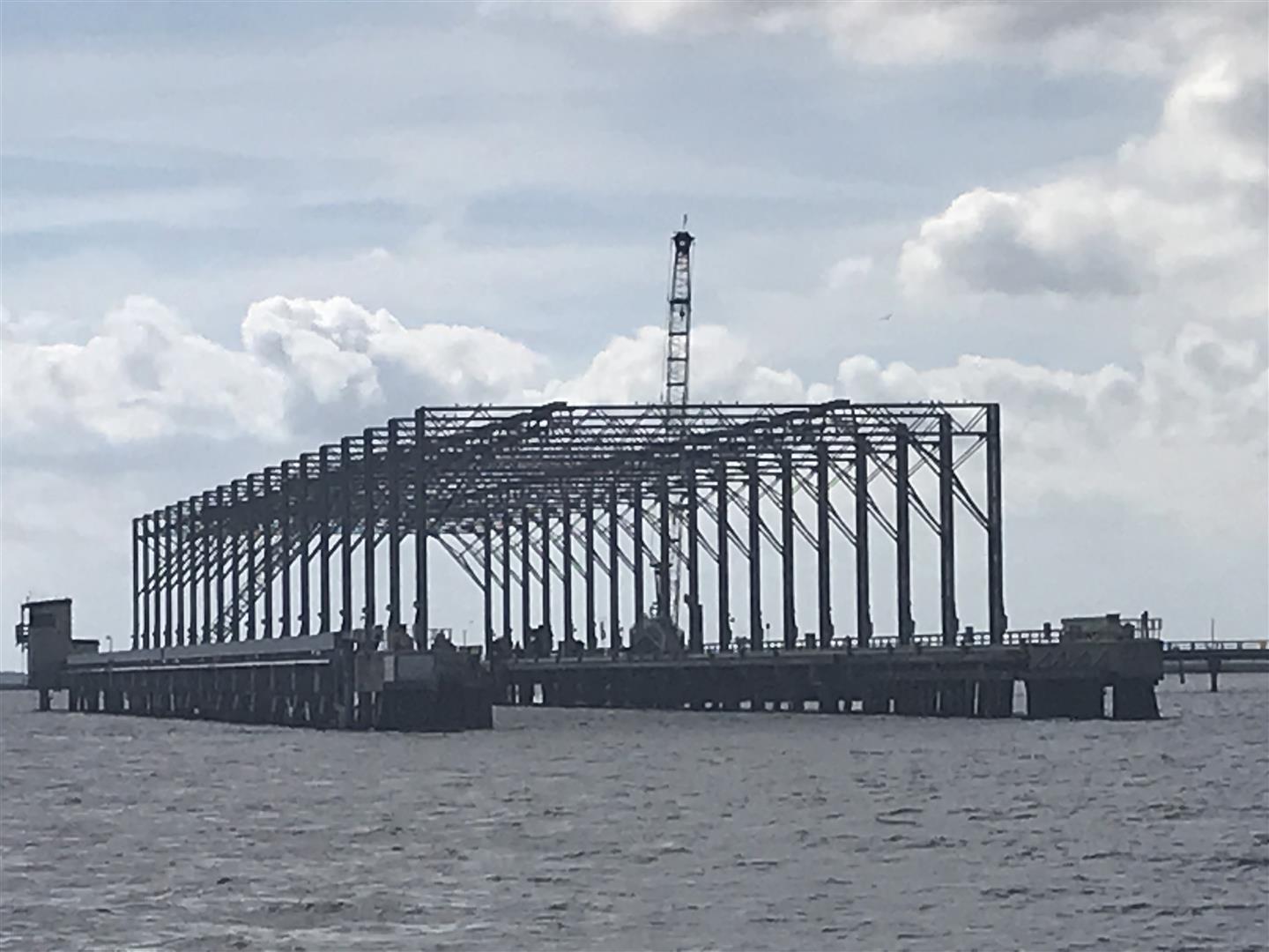 |
| Submarine Repair Pen at Kings Bay |
During
the fueling process we had been eyeballing the local anchorage options and were
not impressed – it was an unattractive industrial area, and quite exposed to
the brisk north winds. Since it was
still only mid-afternoon we decided to back track a few miles to the north and
return to the protected Cumberland Sound area where we had anchored some months
before. By 1530 we had dropped the hook
there but were not comfy with its set….Chelle, from her vantage point at the
fly bridge helm, thought we were dragging.
So
we winched the chain and anchor back to the boat for a second attempt. But as the big Manson anchor came back to the
bow pulpit the anchor’s shank managed to wedge itself between the roller and
anchor guide. The nut on the end of the
big stainless bolt upon which the anchor roller rotates had sheared it cotter
pin and partially backed out, creating a perfect space for the anchor shank to
wedge between the roller and the guide. It was stuck and going
nowhere. Shit.
Rick
scrambled down to the engine room to grab a handful of tools – including a
hammer and crowbar – while Chelle turned Ghost
Rider around and kept her in deep water while we noodled a solution. Eventually Rick managed to dislodge the
anchor from its wedgie, removed the mangled cotter pin, over-tightened the
bolt/nut on the roller, and we found another nearby spot to drop and set the
anchor without shedding any key ground tackle parts.
In the calmer aftermath we determined we had no spare cotter pins aboard
(oops), so Rick fashioned a workaround using stainless steel seizing wire to
keep the bow roller and pin from backing off and falling into the seas.
 |
| A Nice Sunset at the Cumberland Anchorage |
So
we finally settled in for the day, and while it was a little lumpy in the
anchorage with the still-stiff northeast breeze, we relaxed comfortably that
evening
We
had studied the weather forecast the night before, and on the morning of Thursday, 25-October we confirmed our
thoughts – we would not see pleasant conditions inside or outside for the next
two days; so we decided to stay right where we were until this next front
passed. Cumberland isn’t a bad place to
hang on the hook. We had a laid back
morning tending to some basic boat chores and administrative items, then
launched the dinghy. Chelle took the
tender to shore to join Wayne and Kristin (from Kemo Sabe who were anchored nearby) for some walking exercise and
beach strolling over on the Atlantic side of Cumberland Island while Rick placed
some Amazon orders (including cotter pins) and started his search for the now defunct exhaust motor fan for the
master head…with no success after pulling five panels.
 |
| Walking the Beach on the Atlantic Side of Cumberland Island |
That
evening Wayne and Kristin joined us aboard Ghost
Rider for an extended happy hour so we could swap sea stories and other
lies over good drinks and light snacks.
We also shared our experience at the Port Consolidated fuel dock down in
Fernandina since they were hoping to head there tomorrow to top off their tanks
as well. Some light rain moved in that
evening, so we closed up the boat but still had a peaceful and comfortable
night at anchor.
The
morning of Friday, 26-October dawned
with weather as predicted – overcast, windy, with light rain. The winds had finally subsided somewhat so
the anchorage was smooth enough for comfort.
We cranked up the generator per our standard routine and gave the house
batts a good charge, then checked weather forecasts for the coming days. Atmospheric conditions were looking good
beginning the next morning, but the sea forecast was ever-changing and not in a
good way. It was looking like yet another
inside run tomorrow down to St. Augustine.
So
we went to work on the route, carefully cross-checking with hazards noted in
both Active Captain and the Waterway Guide’s resources (where Bob423 also
posts), and made route modifications accordingly. We also checked tides all along the way, and
decided upon a Saturday departure time between 0900 and 0930 to take maximum
advantage of the higher tides as further insurance against the many shoaling
areas we would be traversing.
 |
| An Ohio Class Ballistic Missile Sub Departing Kings Bay for the Open Ocean |
Around
mid-day Chelle went for a spin in the tender but she had to cut it short due to
another approaching line of showers and the potential for thunderstorms. The rest of the afternoon was spent on
administrative items, and between rain showers Chelle did her best to clean up the
dinghy which was looking pretty sad after plenty of use over the past month. We did have one interesting distraction
around 1300 when a small flotilla of U.S. Coast Guard patrol boats headed out
from Kings Bay to start clearing the area for the imminent departure of a
warship. A short while later we saw an
Ohio class ballistic missile submarine rapidly moving down the channel and
heading towards the Atlantic,with a pair of USCG escorts leading and trailing. The Navy
calls those boomers “boats” but with a length of 560 feet and a beam of 42 feet,
it is definitely not a small vessel.
Just after sunset we returned to Ghost Rider for dinner and a ball game (game three of the World
Series) which eventually went eighteen innings and over seven hours….we did not
stay up for all of that.
But the strangest stretch was down near Port Jax as we crossed the
St. John’s River; Kemo Sabe had
hailed us earlier (they had departed about an hour before us) and warned us to
disregard the charts in that area and follow the ATONs visually. That turned out to be very good advice, as
all of our charts were extremely inaccurate in that particular area….at one
point indicating we were boating on top of an island.
Even though the weather was still cool (low to mid 60’s) and with
a stiff westerly wind blowing, you could tell it was a weekend; the Jax area in
particular was busy with runabouts, ski craft and fishing skiffs. But they were all well behaved. South of Jacksonville the ICW actually sported
some scenery, that is if you count rows of one, two and three story docks and big custom
homes in that category. We were also
seeing numerous pods of bottlenose dolphin all the way from Cumberland down to
St. Augustine.
This was the first time we had approached the St. Augustine inlet
from the north on the ICW….and it was confusing as hell in a couple of areas. Just like the Jax area the charts do not
match the ATONs, and on top of that we had sailboats making life a little
challenging. First, as we approached the
Usina bridge where Kemo Sabe had just
warned us 30 minutes before that the depths got a bit skinny, a vessel under
sail suddenly angled in to the bridge, crabbing at an odd offset going in the opposite direction and under the
bridge span. Rick quickly backed Ghost Rider down and made a 180 turn to
let it have the channel, then re-positioned us for a another approach in the ripping
current.
By
early afternoon temps had warmed, so for lunch we walked across the street to
OC White’s Seafood & Spirits restaurant and enjoyed shrimp melt sandwiches
on their open air patio; there’s no shortage of excellent eateries in this
charming waterfront town. After that,
though, it was time to head back to the boat and give Ghost Rider a much needed shower followed by a soapy brushing in
several areas; she was getting rather gritty in spots. What she really needed was another detail and
wax job, but that would have to wait until we returned to Fort Myers.
By 1730 the ugly weather had cleared out so we hopped into the
tender and zipped a few hundred meters over to Kemo Sabe for a
reciprocal happy hour event. We had not been on a Nordy 40 before and
besides enjoying the company of Wayne and Kristin, who are eminently welcoming
and charming, we also got a tour of a classic Nordhavn design. The N40
circumnavigated the planet back in 2002 as one of Nordhavn’s marketing efforts,
so while on the smaller end of the scale, it is a sturdy vessel and capable
passage maker. Its interior layout is also amazingly efficient and spacious.
 |
| Wayne & Kristin's Nordhavn 40, Kemo Sabe, at Anchor Off of Cumberland Island |
 |
| Chelle, Kristin & Wayne Aboard Kemo Sabe Having Some Fun |
On the morning of Saturday,
27-October we retrieved the dinghy, started engines and after spooling in
the anchor got underway just before 0930.
Since it was lumpy again on the outside, our timing was planned so as to
ride down the inside ICW route on good tides most of the day to help us
negotiate some of the shallower stretches, and there were many. Using guidance from Active Captain and the
Waterway Guide (Bob423) we chugged through the nasty areas without incident.
 |
| Passing Fernandina Headed South to St. Augustine....Very Industrial |
 |
| Crossing the St. John's River....Note Where the Channel is Depicted vs. Where Our Boat Symbol Ended Up to Stay in the Real Channel |
 |
| The ICW is Like a Big Canal Just South of Jacksonville with Some Nice Homes and Docks |
Shortly thereafter we encountered the St. Augustine inlet area,
where constant shoaling is cause for relocating the floating channel markers at
frequent intervals: we followed those and what our eyes told us, not
the charts....very similar to the St. John's River experience earler. Then as we came up on the
Bridge of Lions yet another sailboat approached from the opposite direction and at the last moment was given right-of-way by the bridge tender; Rick backed Ghost Rider down
once again to stand off the bridge, but by this time we were past the inlet and
the current was now on our nose, so it was a much easier maneuver.
 |
| Ghost Rider Approaching the St. Augustine Municipal Marina Just South of the Bridge of Lions....Photo Courtesy of Kemo Sabe |
After
that (just past 1700) we had nearly an hour to burn – we did not want to enter the
Municipal Marina with the current running at two to three knots given our tight
slip assignment, so we went down-river for a spell, got our WOT run
accomplished, then turned back to the marina as slack tide/current
approached. As we approached the marina we passed by Kemo Sabe which was hanging on one of the city's mooring balls. We got docked up just before 1800 without
any issues, and other than accomplishing some basic post-flight tasks we deferred
clean-up until the next morning…it was time to relax.
By
daybreak on Sunday, 28-October the
skies were a clear and crystalline blue with a bright sun but a brisk 55F
temperature. It was a perfect fall day
in northeast Florida. After coffee,
donuts, email checks and a depressing news fix, we spent the morning catching up
on boat chores. That included picking up packages, recharging
our SpotFree fresh water filter canister, some laundry, topping off water
tanks, putting a stainless cotter pin back into the anchor bow roller (from one of our packages), and
adding some oil to the main engine to compensate for some of the main seal
leakage over the past month. Kristin and Wayne from Kemo Sabe also stopped by after they had ferried in for a walk through town.
 |
| Ghost Rider Sitting Comfortably and Now Cleaner in Her Slip at the Muni Marina |
After
all that we cleaned ourselves up, performed some final route checking for the
next day’s run down to Daytona, and relaxed with some Goombay Ghosts, wine, and a casual
dinner aboard the boat.
 |
| Our Track from Edisto Island Down to St. Augustine |