 |
| Great Fun with Lots of Batts...Damned Things Weigh 65 Pounds Each |
Rick had plenty of time to plan the routes, which was fortunate as no two chart sets seemed to agree about the best routing through some of the shallow areas on the shoals and shallow banks. In the end we always deferred to the Explorer Chartbook sets, which – as their web site clearly and accurately states (LINK) – are the gold standard for Bahamas cruising.
A few other boats from our Grady-White club joined us for the adventure:
- Ron & Brenda Ingram on their 335 Freedom, Open View (plus 4 guests)
- Bob Chapman on his 335 Freedom, Dilly Dally (plus two guests)
- Tony & Carla Vandenoever on their 306 Canyon, Little
Bird
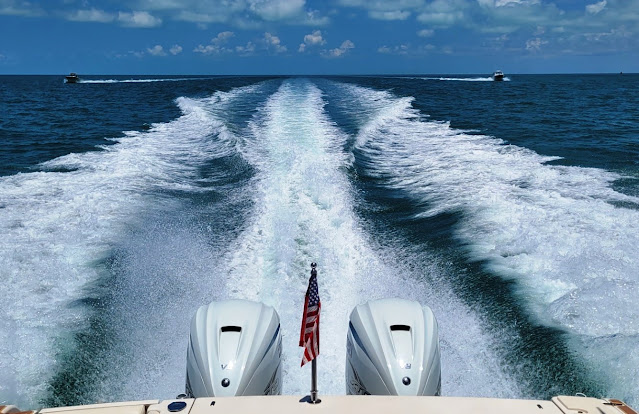 |
| Open View and Little Bird in Trail Behind Ghost Rider En Route to Key Largo |
And aboard Ghost Rider we were joined by Rick’s sister, Lin. So altogether we had 14 folks join the adventure, with planned stops at Key Largo (Florida), Chub Cay (Berry Islands), Cape Eleuthera, and Staniel Cay (Exumas).
Sunday, 11-June: To Key Largo
The first day was all about getting to Key Largo in the northern Florida Keys, so we could stage our Gulf Stream crossing from there the following day. We rendezvoused at the Sanibel Causeway at 0900, with Open View and Little Bird falling into formation behind Ghost Rider (Bob on Dilly Dally had departed the day before) and headed south in perfect weather conditions – a warm, summery day with light breezes and flat seas, and only had to deviate slightly for one heavy shower in Florida Bay.
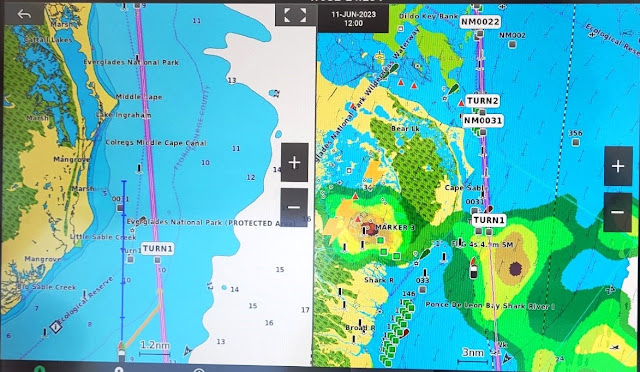 |
| The Weather We Dodged as Shown on the XM Satellite Display on the Right |
After clocking 155 nautical miles we were topping off fuel tanks in Key Largo by 1500, and then docking up at Marina Del Mar for the night. We enjoyed a group dinner at Skipper’s dockside restaurant, checked the next day’s weather forecast (good enough), enjoyed a night cap, and got some sleep.
Monday, 12-June: To Chub Cay
We were off the dock by 0800 and motoring east shortly thereafter. A few storms were draped along Florida’s southeast coast, but out in the open water we had good weather again. But sea conditions were pretty lumpy for the first half of the crossing – quartering off the starboard bow at 2 to 3 feet, with the occasional 4 footer tossed in just to juggle your eyeballs a bit. Initially that required deploying full trim tabs, but eventually the 15K winds clocked around to a southwesterly flow, and the ride improved (much to sister Lin’s relief.) After we cut through the shoals at South Riding Rock (about 20NM south of Cat Cay), the ride improved even further. We managed our route to bisect a couple of small thunderstorm cells shortly thereafter, and arrived at Chub Cay at the southern tip of the Berry Islands around 1430.
 |
| The Long and Rather Bumpy Leg from Key Largo to Chub Cay |
The check-in process there was chaotic –
an impressive thunderstorm lashed the area shortly after our arrival, systems
were slow and the Internet was sclerotic.
Eventually we got a ride to customs and immigration located at the
nearby airport, after which we took down the Q-flag and raised the Bahamian
courtesy flag. We had dinner on the boat
and crashed for the night.
 |
| It Stormed Heavily Shortly After We Arrived at Chub Cay |
Tuesday, 13-June: To Cape
Eleuthera
All boats spooled up at 0745 and headed
to the fuel dock to take on more fuel before the next 102 NM leg to Eleuthera. The Chub fuel dock was rationing, limiting
each boat to 120 gallons, but that was more than enough for the day. By 0900 we were underway again and headed
southeast through 2-3 foot seas and sunny weather towards New Providence Island
and Nassau, the capital of the Bahamas.
We skirted around Nassau Harbor via a skinny passage appropriately
called “The Narrows”, going from a few thousand feet of depth to a section of
the Great Bahama Bank that averaged about 14 feet deep – except where coral
heads sprout upward to just a few feet below the surface.
 |
| Our Path From Chub Cay to Cape Eleuthera |
But we managed to keep the boats off the
bottom, and cut through another narrow passage at Highbourne Cay to cross over
into Exuma Sound, where depths once again were measured in thousands of
feet. From there, a 25 NM jog to the
northeast brought us to Cape Eleuthera around 1330. Tony and Carla in Little Bird went
about 10 NM further to the northeast for their lodging in Rock Sound.
Cape Eleuthera is a large, well-protected and deep harbor. Its fixed, wooden docks were in good condition, and all facilities – guest cabins, pool, beaches, restaurant, laundry and showers – were equally well kept. We spend a couple of relaxing days here enjoying the two beaches and pool (it was hot) with a side trip into town (not much there), and a group dinner at the marina restaurant (good food.)
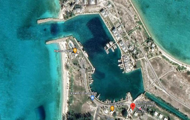 |
| An Aerial View of the Cape Eleuthera Marina Basin |
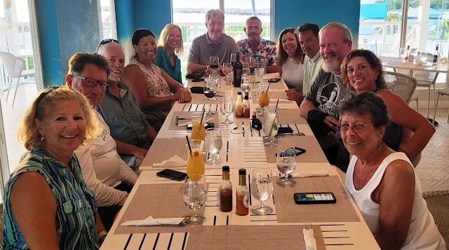 |
| The Group Dinner at Cape Eleuthera's Harbor Point Restaurant |
On the second day we took Ghost Rider about 10 nautical miles to the south, near Davis Harbour on the west side of Eleuthera, to check out the fishing. In that area the water depths drop off sharply very close to the shoreline, and trolling the ledges can produce some nice fish. We lucked into a swarm of bait-feeding sea birds and found ourselves with a double-header hookup. Whatever was on Chelle’s line bit the leader in half (Wahoo or Barracuda?), but Rick’s line produced a nice 30-inch Mahi.
Friday, 16-June: To Staniel Cay
Since our next leg was a short one
(about 40 nautical miles to the southwest), after a mid-morning departure from
Cape Eleuthera we first diverted north and east about 10 miles towards Rock
Sound in search of a plane wreck site to snorkel. The GPS coordinates that Ron had provided
were accurate, and in 10 feet of very clear water the plane’s wings were easy
to discern, providing structure for a variety of sea life. From there we went a few more miles further
east into Rock Sound, in search of a “blue hole” that Bob noticed on the
Explorer Chart. It took a little dead
reckoning and all four boats in an impromptu search pattern, but eventually we
found it – a circular sinkhole depression in an otherwise flat limestone
seabed.
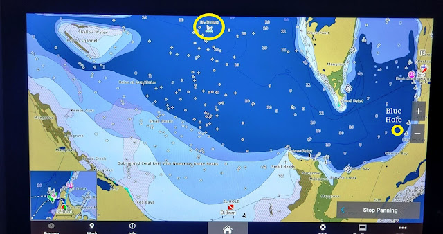 |
| The Yellow Circles on the Chart Display Mark the Plane Wreck & Blue Hole Locations |
The chart indicated the hole had a
16-meter depth (50 feet vs. the surrounding 6-8 feet). These holes occur all over the Bahamas, but
generally don’t feature much sea life, as they tend to be anoxic with poor
water circulation. As blue holes go in
the islands, it was quite modest – “Dean’s Blue Hole”, about 140 miles south of
this one, is the world’s second deepest at 660 feet.
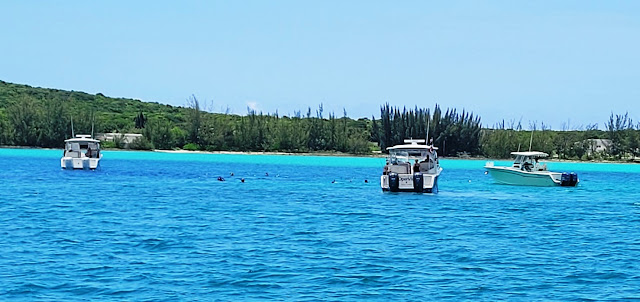 |
| Snorkeling the Blue Hole |
Shortly after noon all boats retrieved
their snorkelers and we headed south and west to Staniel Cay in the Exumas
chain. In smooth water and pleasant weather
we were at Staniel Cay Yacht Club (SCYC) in under two hours. Once there, however, it took another hour to
get dock assignments and tie off – their staff and dock hands were definitely
on “island time.” Visitors should note that
the current absolutely rips through this area, and you can find yourself
drifting into very shallow shoals if you don’t pay attention.
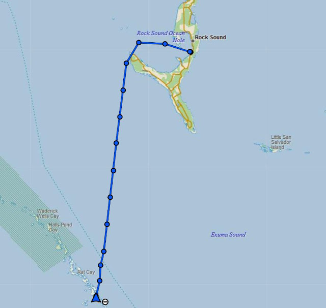 |
| Our Track from Eleuthera/Rock Sound to Staniel Cay |
 |
| An Aerial Shot of Staniel Cay Yacht Club (SCYC) |
Staniel Cay is a small island – about 1.7 miles in length, a half mile wide, just big enough for a 3,000 foot runway, with a small and mostly unprotected marina (SCYC) bolted on to its west side, and some small cottages perched on its steep slopes. It’s likely none of that would be here except for a few famous nearby attractions just to the north: the Thunderball Grotto, and Pig Beach on Big Major Cay.
Of the two, the grotto – a series of underwater caves – is definitely the better experience, and well worth the long journey to get there. Significant tidal flows and resultant currents don’t make that simple (wait for low tide and slack water), but once inside, it is rather stunning. We rented a small Boston Whaler skiff to make it less of a hassle, but even then the smooth limestone seabed makes setting an anchor in any kind of current a real challenge. You can read more about the grotto at this LINK, along with some of the movies filmed there (including its namesake 007 movie.)
Not far away, about a 1.5 mile boat ride
to the west and north, is Pig Beach (LINK). Uninhabited (well, except for the feral pigs
and transient touristas), Big Major Cay’s other significant draw is its large
anchorage, protected on three sides; dozens of monstrous yachts were moored
there.
As for Pig Beach, it would be more
accurate to call it Hog Beach, as most of the swine there are large and very
well fed, and definitely not shy; several of them were suitable for a riding
saddle. You can hand feed them, but if
you don’t and have food in hand, they will come and take it anyway (as sister Lin
discovered), without much regard for your desire to remain upright. And yeah, they can swim.
The next day we were planning to join Ron aboard Open View for some fishing in Exuma Sound, but the weather didn’t cooperate. Thunderstorms, with high winds and lightning, swept the area most of the day, and the boats got rocked pretty good by the southerly wind-driven waves. It turned out to be a good day for a nap in the air conditioned cabin. Since we were staying aboard the boat, and SCYC had no shower facilities, we made use of Lin’s cabin for nightly showers; while it was small, it was clean and bright, with a great view of the harbor area – she loved the idyllic setting. We had dinner at the marina restaurant one night (good food, but you had to submit your order by 1600 and reserve either the 1830 or 2030 seating schedule), but we otherwise prepared meals on the boat.
 |
| Lin's SCYC Hillside Accommodations at the Chamberlain Cottages |
 |
| And It Came with a Nice Water View |
The afternoon forecast for the Chub area wasn’t promising, so we got an early start at 0730, made our way back through the narrow cut into Exuma Sound, and scooted up the east coast of the Exuma chain until we got to Highbourne Cay. From there we joined the reversed route to Chub, cutting across the shallow banks again, back through “The Narrows” just east of Nassau, and from their motored in deep water to Chub. Seas were a little sloppy at 2-3 feet, but following off the stern. All boats topped off at the fuel dock (no rationing this time) and got tied up at the floating docks before storms raked the marina once again.
 |
| Our Track from Staniel Cay Back to Chub Cay |
Tuesday, 20-June: Back to Key Largo
The weather and sea forecasts for the
return trip to US waters were looking very good, but all boats wanted to try
some fishing in the Chub area before making that dash….so we got started early
around 0730. The four boats fanned out into
the deep water – just east of the banks and north of Andros – known as “The
Pocket”, supposedly renowned for holding all sorts of pelagic fish. But as with our attempts last year, nothing
materialized over the next 90 minutes.
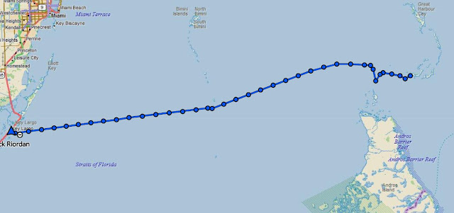 |
| Our Track Heading Back to Key Largo with a Deviation to Troll in "The Pocket" |
All four boats rendezvoused once again
at 0900 at the Northwest Shoal lighted marker, Ghost Rider took the
lead, and we headed west, making good time in smooth waters at 32 MPH (about 28
knots on the GPS). After crossing into
the deeper waters of the Gulf Stream through the Riding Rock cut-through, we
continued to encounter flat seas and arrived at the Largo canal entrance around
1445. Ghost Rider had no issues
taking on fuel, but the pump ran dry shortly thereafter so others had to head
one canal south to the Pilothouse Marina for gas. We had one last group dinner at Skipper’s and
then slept well.
 |
| Flat Seas in the Gulf Stream Heading Back to Key Largo |
Wednesday, 21-June: RTB
This was RTB (return to base) day for
us, with the exception of Dilly Dally, as Bob planned to spend another
day or two with friends in Key Largo. Open
View and Little Bird sortied out at 0800 since they had a longer
distance to traverse back to PGI and Port Charlotte. Ghost Rider’s crew slept in a bit and
departed solo at 0900.
The run home was uneventful until we came abreast of Naples on the west coast of Florida around 1400, at which time both XM satellite weather and the radar set showed a healthy thunderstorm parked along our route near Fort Myers Beach. There was plenty of lightning visible, so Rick slowed the boat to a crawl to give the system time to either move or dissipate – he also thought he sighted a waterspout at the storm’s trailing edge near Sanibel at one point, but kept that to himself. (LINK to video).
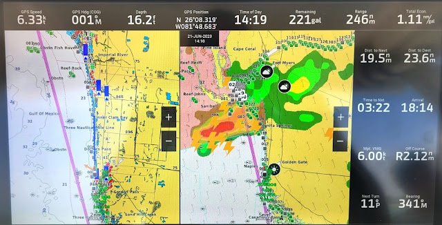 |
| This Thunderstorm Could Not Have Parked Itself in a Worse Spot |
About
45 minutes later the storm had split into two cells and dissipated enough to
create an alley between them and the coastline that we could run without
concern. And by 1600 we had completed
our RTB (as had Open View and Little Bird). Bob in Dilly Dally returned home two
days later (also successfully dodging a thunderstorm along the way.)
Afterword
This was a fun and challenging expedition.
We thoroughly enjoyed the company of our fellow club members, the journey and the destinations. And as with most adventurous outings, preparation is as key as the doing. Anyone contemplating such an excursion is advised to spend at least twice as much time in planning readiness as in anticipated execution. Whether it’s customs and immigration requirements, or provisioning and spares, country-specific protocols, weather routing, charting and plotting, safety measures, pre-trip maintenance, whatever – there is plenty of prep and anticipation required. The fun is in pulling it all together and making it a smooth experience once underway.
By the way, Chelle did a terrific job of provisioning our boat and crew for the travels….we had plenty of libations, fresh water, food, clothing and basic supplies all the way….not an easy feat for liveaboards on a small boat in the Bahamas. She’s the expert for folks who want counsel on such things. And special shout-out kudos for her “Ever*Chill” instant ice-maker – that thing was totally awesome….one cannot enjoy good scotch or a Goombay Ghost without an ample and predictable supply of ice cubes.
 |
| These Were All of the Charts Used to Plan & Plot the Trip |
Over the 11-day voyage we covered nearly 900 nautical (about 1100 statute) miles, consumed more than our fair share of scotch, rum and wine (after sailing hours at the dock, of course), and burned a lot of fuel – in Ghost Rider’s case, about $5,600 worth. We were happy to contribute to the American and Bahamian economies, and it was positively well worth it.
Our next sortie to the Bahamas will likely be back to the Abacos, timing TBD, more on that later.
 |
| We Exported Our Tracks from the inReach Tracking Site & Imported into Google Earth for This View of the Entire Journey |
Here are a few other pics from the trip....
 |
| Sister Lin Enjoying a Smooth Run Enroute to Key Largo on Day 1 |
 |
| Cape Eleuthera |
 |
| Cape Eleuthera from the East Side (Sunrise Beach) |
 |
| Lodging at Cape Eleuthera |
 |
| At Cape Eleuthera Looking West at the Harbor Entry |
 |
| Cape Eleuthera Pool Area at Sunset |
 |
| Little Bird, Dilly Dally, Open View and Ghost Rider Docked at SCYC |
 |
| The Chamberlain Cottages Near SCYC |
 |
| Our Four Grady-Whites at SCYC as Seen from the Shoreline |


A very well written, informative overview of the trip. Thanks so much for sharing the trip with us. Well done to all.
ReplyDeleteJayne passed along the link for me to see. That looks like an incredible adventure you had on the Bahamas trip. Your descriptions and photographs were terrific. It's evident that you put a lot of effort into planning and executing this trip. Thank you for sharing this experience and kudos to you and your crew for a well-done voyage.
ReplyDeleteHoward
To those who have commented and/or read this Blog, I can tell you from first hand experience no one does it better than Rick & Michelle. Their skillsets, computer and electronics background, organizational abilities and an oversize dose of seamanship make them the best guides you'll ever find.
ReplyDeleteI can personally attest to many great cruises, enjoyable evenings in the stern cockpit telling stories, and a reasonable amount of knowledge gained from their company.
Ever an abstainer from alcoholic beverages, I can personally recommend their personal concoction, the "Goombay Ghost." I had half a glass or a little more one evening, and the boat was rocking dockside in a dead flat calm. (or so I thought....)
Because of my chosen entertainment profession, I have come across more people than I could ever recount. Many of them I enjoyed hanging with, several I never wanted to see again, and most came and went with the Passage Of Life. I have a few Special Ones that I will always look back on with love.
Rick & Michelle (The Pirate Princess) are ensconced in my Special Circle. God Bless Them Both.
Hi Bill! Thanks for the kind words. We miss you, too....
ReplyDeleteDear Rick & Michelle--Loved reading this and marvel at your excellent record of this terrific voyage! From all of us at Grady-White, here is a toast to your adventurous spirit and a big thank you to you and the club for choosing Grady-White boats!
ReplyDeleteWarmest regards, Shelley Tubaugh, VP Marketing, Grady-White Boats
Shelley....thanks for the positive feedback!
ReplyDelete